|

|

|

|

|

|

|

|

|

|
Richings Park today ...

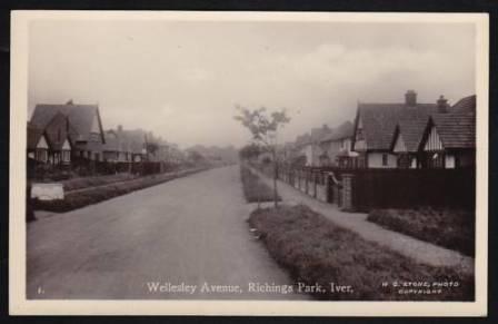
Wellesley Avenue 2011
Thence to the A4 and back to Langley.
In more recent times the A4 and A40 became major roads and source of increasing traffic and then came the motorways - the M4 in 1963 and M25 in 1986. In addition to the resulting pounding traffic, these roads have bounded and carved up our locality so that it not easy to image how free, open and peaceful it used to be.

Wellesley Avenue
The present street names were an attempt by the Sykes brothers to preserve what they felt to be some of the important historical connections: Bathurst Walk, Somerset Way,
Wellesley Avenue, The Poynings. The new straight stretch of road, cutting off St Leonard's Walk (the original Thorney Lane) was briefly known as Hache Way. The early names of Syke Ings and Syke Cluan were Northumberland Avenue and The Earl's Walk. One early brochure mentions and has photographs of Fitz-Payne Avenue and Beauchamp Avenue. The new development of Northumberland Walk (off Syke Cluan) maintains this tradition.
Syke (sike) is the Anglo-Saxon word for a ditch or water course and still in use in Yorkshire; an ings was a meadow next to a syke (in Scotland a cluan). Much of the land was originally meadow prior to the building of the estate. The first residents of Richings Park recalled a small stream in a ditch running along what was Syke Cluan before it was made up. The co-incidence with the name of the Sykes brothers was well taken.
Building after the Sykes
51 - 61 Syke Ings and 46 - 54 Syke Cluan. These house were built around 1936-37. They stand back to back at the point where these two roads begin to converge. This is where the 30m contour line swings east to run along Richings Way to the Tower arms. Their site used to be a small, pre-Richings Park Company gravel pit. Here the Sykes brothers intended to build Tudor Court stating "it will be completed next year" in their promotional hardback book Richings Park - its message - houses without deposit published by the Estate Company in 1927. A double page, colour centre-spread gave a perhaps fanciful artist's impression by Clare of what this would look like: there was to be a triangle of 4-8 house Tudor terraces and a lake (with island) in the middle. It is not clear how it would all have fitted in! Instead the gravel pit was filled in and houses now on this site had to wait until the ground had settled enough to be built on.

